
Tenting out last night I was hoping to wait for the next hut 8km away for my ablutions but, when nature calls...
Fortunately there was a rabbit hole ideally placed. No digging required on my part, but no doubt one very shocked rabbit. Never mind, quid pro quo for all the rabbit droppings I've been walking over for the last 4 days.

The walking day started with an easy 5km of picturesque trail...
... before dropping to the Coal River and some fairly slow route finding upstream and an impromptu swim by Neil.

 Within 90 minutes we'd made it to Camp Stream Hut, a fantastic little private hut with a large stack of fire wood that would make for a brilliant little weekend destination in from the Roundhill road end. We were only staying for lunch, but the $10 cost of staying there would have been well worth it.
After lunch, like most TA walkers, we left the official trail which followed a valley, instead climbing onto a sublime ridge with magnificent 360 degree views. Only a matter of 20km to the northwest was Aoraki, the other mountains bordering the Grand Plateau and the main divide. Unfortunately on our day this was largely hidden in cloud, but such was the scenery that this hardly detracted from the grandeur of the scene, with 2500+ meter high mountains dotting the landscape at seemingly all angles.
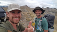 The ridge was some of the easiest climbing on the trail so far, a really easy gradient and took us across the 650km mark on the trail. HALF WAY!!! So momentous that it called for an inter centenary thumbs up.
 As always the views kept improving as we climbed. The high point on the whole trail is Stag Saddle at 1950 meters. It seemed a shame to top out just below 2000, and with the newly named Beuzenberg Peak (named after a Mt Cook guided, deceased on a fall with 2 clients) easily climbable from the ridge at 2070 meters we carried on up. Feeling privileged to stand in such a place I started to reel off photos, none of which really capture the majesty of the place.


Then it was down a long scree slope on the other side of the mountain. We had 700 meters of altitude to lose, and only 4km to the hut to do it in.


The day was bookended by another hour and a half of difficult river route finding. I was getting tired and this section seemed to go on forever.

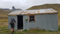 But we eventually made it to Royal Hut, so named because Prince Charles and Princess Anne were once choppered in here for tea. I think I earned it more!
No comments:
Post a Comment