Wednesday 7 February 2018

Day 13 - Kiwi Burn Hut to North Mavora lake campsite, 17.2km, 5 hours 50 minutes


With a shorter day in prospect there was a bit of a sleep in today, and a lot of mucking around. We probably weren't on track until 10:30.

Stephen's feet were still suffering, and with a tight calf now to go with it we made slow, deliberate progress to minimize any further damage. Fortunately Elijah seems in good nick with no particular issues. He has fastidiously been keeping up his stretches to minimize the possibility of his Severs Disease playing up.

We spent most of the day following the Upper Mavora River. As we approached South Mavora Lake the river became quite spectacular.
First there were some fearsome looking rapids, bigger than just about anything I've seen in the South Island, and to me somewhat reminiscent of the rapids above the Hooker falls on the Waikato River (albeit with less flow, obviously).

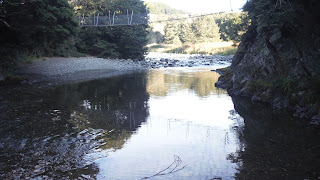
Further on still, and now quite close to the lake, the river still had a fast current, but was now deep and clear. It looked like it would be a trout fishing mecca.


... and so to South Mavora lake, a thing of beauty, for a very late lunch. I wasted no time in quickly jumping in where the Mavora River flows out, although care was required, there is quite some current.


Stephen and Eli took the opportunity of exiting via a swing bridge to the Mavora road, and hitching the 6km up to North Mavora lake to save Stephen's feet. I carried on along South Mavora lake and found the going very easy, knocking the distance off in under an hour.


After some confusion after we set up different camps at each end of the kilometer long camping ground, we eventually found each other and settled down for the evening, but not before popping into the lake for a quick swim.


Both lakes are exceedingly beautiful. Camping here would be amazing!

 We are pitched within meters of a Lord of the Rings site - if you're familiar with the films, where Frodo and Sam leave the fellowship by rowing across a river, after having hidden in the trees from orcs. Interesting stuff!


Two more short days in store. I'm really looking forward to enjoying the lake some more tomorrow.

Day 12 - Te Anau > Mavora Lakes turnoff to Kiwi Burn Hut, 27.5km, 8 hours 30 minutes


This section through to Queenstown was intended to be walked with my cousin, Caleb. With his tragic death just days before coming away on this walk, this part of the trail was always going to be extremely difficult for me. However my brother, Stephen; and son, Eli, have stepped up and joined me for this section in Caleb's sted. It's not going to stop things being painful, that's for sure, but it's going to be much better than mucking through it by myself. I'm very grateful to Stephen and Eli helping me out like this.

In a sense Caleb came along in spirit - Stephen brought along Caleb's bottle of excellent single malt whiskey with a couple of swigs in the bottom, which we polished off in Te Anau over reminisces of our life with him, and regrets over his lost future. We've decided that tramping together without Caleb will always hold regrets for us, as being a time when he would likely be out enjoying the experience with us. We need to find a way to embrace that and make it a positive thing, rather than dwelling on it. I'm currently thinking about always tramping with nips of that same whiskey with Stephen so we can have a tot together once the day is done.

To the walking.
We had an early morning fright when Eli, who had tweaked his ankle, found it unimproved in the morning, with him barely able to put weight on the foot. Amidst panicked arrangements to try to get Eli home to Christchurch while simultaneously rearranging track transport, I sent Eli for a 15 minute stroll to try to walk it off. He came back declaring it good, be so the trip was back on as originally planned.


Once on the trail, actually a long shingle road into the Mavora Lakes, and having dodged a nutty school bus driver who took the turnoff corner near on 2 wheels before slamming his brakes on hard and skidding to a halt beside us (I presume he doesn't like walkers using 'his' road), we started off at a good pace.
With 4 days rest, and 10 days food on board (5 days each for Eli and myself), my pack felt heavy at first, but quickly settled down to feel somewhat normal.

With snow down to low levels on the mountains we were walking towards we experienced cold winds throughout the day - not unpleasantly cold generally, but certainly enough that my long sleeved merino stayed zipped up most of the day.

It has been cold enough in Te Anau recently that I nixed plans to send some of my warm clothing home, preferring to hold onto it until at least Queenstown.

For morning tea I pulled out a Boston bun as a surprise. It had turned into a Squashton bun (no surprise there I guess), but was no less edible for all that.

It was another 50/50 day weather wise, but this time it never really settled into any pattern, with a few light showers at times, but generally excellent walking conditions.


It was easy walking as we approached the mountains, clearing off the road from time to time as a vehicle came along, but not very exciting, so few photos to worry about clogging up memory cards today.

At lunch time I had a bit of a rude shock. I did a boil up for lunch, but it turns out Eli had brought no eating utensils; plate, bowl, cup, spork. Nothing. Fortunately we can share my cup and pot (which is also my bowl) without too many problems, and I happened to bring a spare spork, realising it would be a real issue if I lost mine.


It has been, and continues to be, my plan to walk every step of the South Island's length. However I realised over lunch I may have made a mistake. When I walked down to the Mavora turn off after coming out of the Takitimus, I never crossed the road to where we were dropped off this morning. So I've missed about a 10 meter section, the width of State Highway 94. A small enough mistake I'm not going to beat myself up over it.

It was my intention to lower the kilometers we did per day through here to give Eli, unused to long distance tramping, an easier time. However as we approached the area I'd picked out on the map where we'd start looking for a campsite, both Stephen & Elijah were keen to push on to the hut, at least another 8km further on.

I had walked the whole day in sandals, and was feeling fine, feet in no worse condition than the start of  the day. Conversely Stephen's feet suffered from the gravel walking, especially through this last part of the day.

He soldiered on however, and eventually we came to where the Mavora River needed to be forded to get to the hut. I had spied what I took to be a fisherman's access from the road. Reaching this turnoff I sauntered off a couple of hundred meters towards the river, only to be surprised when I came into a farmyard, complete with farmer. Apologising for barging onto his land, I was relieved when he readily acceded to my request to complete our crossing to the river.

The river was in high flow, but looked OK. Gratifyingly, mountains of didymo were being washed downstream, although with the prodigious amounts still holding onto the rocks of the river bed I would imagine it will take a serious flood to somewhat clean the river out after this dry, low flow summer. We took the precaution of linking up with packs unclipped - the flow was fast and to the bottom of our shorts - it would not have taken too much more water to have made the river not crossable in safety.

There followed a kilometer or two of easy bush travel. Stephen's feet were really suffering by now, and he went bare foot with gaiters for the last section, an interesting combination.


Fortunately it didn't take much of this before arriving at the Kiwi Burn Hut, our destination for the night, after a not at all shorter day.

Never mind, it will make for some very short days as we go through the lakes, so hopefully gone Stephen's feet time to recover once off gravel roads.


The hut is very agreeable and we have the somewhat unexpected pleasure of having it to ourselves. It has a nice little pot belly stove, which, given the rain and temperature, we've fired up for the evening - it has a tiny firebox so will be difficult to keep going for any length of time.

The day ended with some more pack repair. I'd overfilled one of my outer accessible sections, and the thread had started coming away. I must remember to get some more thread in Queenstown.

A very short day beckons tomorrow, so I'll be sleeping in as long as the sun allows.

Thursday 1 February 2018

Hiatus in Te Anau


I arrived into te anau feeling exhausted, helped myself to a 2 scoop ice cream while checking into the top 10 for the only thing available - a queen motel room.  After a bit of a rest I pulled myself into town to get a slap up lamb meal at a newly opened Argentinian bbq.   The food was ok, but nothing to write home about, but at least there was enough left over for breakfast.

With accommodation at a premium I donned pack the next morning for the 2km jaunt down the other end of town where I'd booked a single cabin for the next 2 nights.

I wasn't feeling well, and shortly after checking in I found out why, developing the shakes.  Herein followed 24 hours of running a temperature and frequent trips to the loo, with concerns about my ability to walk the next section when Stephen and Eli turned up.

Fortunately however it was a pretty short run thing; a day later I was feeling wiped out, but in recovery enough that I was able to start eating and had a couple of shortish swims in the lake (lake Te Anau being the warmest I'd ever felt it).

Today the rain has set in and I'm having a lazy day, having put the final touches on my resupply, and splashed out on a more suitable inflatable bedroll).  Stephen and Eli turn up in a few hours, so I'll be heading into town shortly to meet them.  Jacket and boots will be required!

Next update will be back from the trail, but you probably won't see it until I'm in Queenstown.  In the mean time Jakob will continue with his excellent work uploading my satellite position.

Wednesday 31 January 2018

Day 11 - Aparima Hut To Mavora Lakes Turnoff > Te Anau, 25.5km, 8 Hours

The Takitimu's are a beautiful mountain range.  The TA traverses a spectacular basin before exiting to the Te Anau road.

Well the mind worm song guy had a new number in his head this morning, "Be my, be my baby". hmmmm.

I was itching to get into Te Anau so made another early start.  Normally when I'm tramping I get a craving for steak and chips, but I haven't really had any food hankerings yet, except maybe for a fresh apricot.  Be that as it may, food is definitely the default conversation piece around the huts at night.  All that to say, I'm not itching to get into Te Anau to have a feed (although I'll certainly be doing that), more to ring home and have a decent conversation.

To the tramping.  In short, a phenomenal day, one of the most enjoyable I've ever had.  The Takitimu mountains are a hidden gem!  Difficult to get into, but spectacularly beautiful and worth the effort.

The day started misty but cleared just as I dropped into an enormous cirque, surrounded by mountains on all sides.  It truly felt like a natural coliseum.  Every couple of minutes of walking would open up some superlative new view, to the point where it felt I was spending as much time photographing as walking.


The morning's walk consisted of traversing this cirque and was pretty easy going, tussock country mixed with some forest sections, with a bit of route finding thrown in for some fun.  I would imagine in a standard year this could actually be a very difficult route of an extremely boggy nature, but in this very dry summer it was no more than moderately challenging.  The trick was to go slow to be fast, often pausing to survey the best route ahead.

From time to time I managed to escape the chest high tussock onto mossy sections, normally easy walking, but this was so thick it was like walking on a trampoline.  Still easier than the tussock though!


The roar isn't supposed to start for a bit yet, bit I could hear plenty of stags letting go as I walked.  I can see why this area is popular with hunters!

One was used as a very effective arrow.


After 4 hours and 12km of some of the most glorious walking I've ever had, I started to climb out of the cirque towards Princhester Saddle.  Tough going!  1.5km covered in the next 90 minutes.  Spiders must love this forest.  The kayaking couple had left before me, so I wasn't first on track for the day, but I was still getting a faceful of spider web every 2-3 minutes.  Meeting a SOBO going the other way it was the first thing she mentioned too.

After some time negotiating the often treacherous route down from the saddle, and still seemingly deep in the bush, I heard the glorious sound of sheep bleating, the signal that the end of the track was nigh.

A very nice hut, Lower Princhester, sits at the trailhead, accompanied by a very pretty stream.  It'd be a fantastic place to spend the weekend if you lived close by.

From here there was an easy 6km road walk out to the main Te Anau Rd, which if nothing else provided a good view of the saddle I'd just come over.


... and the novelty of the world's most useless cattle stop.

Once on the Te Anau road I opted for an extra 3km along to the Mavora Lakes turnoff, where the next section would be starting from.  No point making Stephen and Eli, who will be joining me for Te Anau through to Queenstown, walk that bit.

Waiting for the bus at the crossroads was not a pleasent experience.  90 minutes in 30+ degree heat with not even a hint of shade.  At least it gave me the chance to go full tourist again when the local farm decided to do a sheep drive right across the crossroad in front of me, something I remember happening all the time while on holiday as a kid, but it seems you hardly see now.

I'm now into a 4 day hiatus in Te Anau, back on the trail on the 2nd of February, for 5 days through the Mavora lakes to Queenstown.

Tuesday 30 January 2018

Day 10 - Apirama Hut, 0km


After 5 days on the move and a big push yesterday it was time for a zero day (track parlance for a rest day, as in 0km travelled).
A lazy day of reading, watching the Poirot TV series, and chatting with the other 3 hut residents followed, punctuated with 3 trips down to the Apirama Deep for a swim, 300 meters away.


The hole is only about 1.5 meters deep at it's deepest, but is about 20 meters long, so is perfect for a bit of swimming or just lazing around between the water and sandy/stoney beach on one side of it.
After a long lie in I went down for a morning wake me up about 8.30, a longer swim/laze/sunbath in the early afternoon, then a pre dinner refresher.

We have a merry party this evening.  6 NOBOs in total and, remarkably, all kiwis (even Neil has a NZ passport).  To put that into context, something like 20% of the people I've seen doing the trail have been kiwis. 

Some really interesting people in, including a guy (directly behind me) who kayaked with Ferguson and McDonald in the 80's and now works as a builder on Hollywood movie sets.  Made for some interesting conversation.  Alas, another who hasn't been able to get the song "Stand by your man" out of his head all day, something like a stuck record.  The conspirational part of me wonders if this is a subconscious, subliminal message to a youngish girl he has started walking with along the way, and is rather mentoring along, to the point of preparing all her food and sharing water bottles. 

I've just finished strapping my feet ready for the off tomorrow.  A SOBO has given me an alternative from second skin to use for the blisters, so I'll be trying that with interest tomorrow.  Next stop Te Anau!

Day 9 - Telford Burn Camp to Aparima Hut, 21.6km, 10 hours 35 minutes

It wasn't yet dawn when I got up, the sky just starting to lighten in the east.  I was determined to break the crux of the climb before the day heated up too much - I'd be sweating enough as it was.  
So after a quick breakfast and packup I was on the trail by 6.30, pack and, more importantly, left heel feeling great.  
It was steep country, but with an open hillside leading onto a wide ridge, it was choose your own adventure stuff.  I responded with shallow zigzags to lessen the slope and within 45 minutes had the first 300 meters (the steepest part) done, before the sun hit me.  As an added bonus once I hit the ridge leading to the summit I was hit with just about the perfect breeze to keep me cool.  All in all a great day so far!

Like what tends to happen when you're climbing mountains the view just kept getting better the higher I went, resulting in many photographs of largely the same scene.


Towards the top the ridge narrowed, a more direct route dictated.  Ironically, even though less steep than earlier, this probably made for tougher going.  Nevertheless the top beckoned. A flock of magpies and a stunning view were waiting for me on the summit.  I could just make out the sweep of Colac Bay away in the distance.  It was satisfying to say the least to survey the distance travelled in the last few days.

Once over the top it was into the bush for 4km of meandering down to the Lower Wairaki hut, reached after 4 hours from the campsite, and the normal stop point for the day.    

However I was keen to get on to the next hut to sample the wonders of the Apirama Deep, the name I have decided to bestow on this as yet unseen swimming hole further on.  Even so I had a break here for a couple of hours.


As I was sunning myself on the hill an Irish fella sauntered up and introduced himself.  He and his girlfriend are NOBOs and were camping down the hill by the river.  Apparently a refreshing place to throw yourself.  I needed no second invitation and was down having a dip a couple of minutes later.  Then back to the hut for a boil up.

2 hours into my second stint through to Apirama hut the big climb this morning suddenly caught up.  The fires went out, and from that point the afternoon was hard yakka.  This was unfortunate timing, because I was about to embark on the most soul destroying track I've ever been on.


Some background.  On a 1:50000 topomap the relief lines are drawn for every 20 meters of height.  If your trail is running perpendicular to the relief lines, you're going to be either climbing or descending.  If your trail is running parallel to the relief lines, you're in for a pretty easy time of it.  Here's the relief map for part of yesterday afternoon's walk.

It looked pretty easy going, hence the decision to push on to the next hut.  However the track was actually a never-ending series of what seemed like flood tracks.  Each was 20-25 meters high, each started immediately after the previous one had been descended.  The thing, is because of their height they didn't show up on the topomap and they were completely unexpected.  I stopped counting how many once we'd done 30.  At a conservative estimate that's an unexpected 600 meters of extra climbing.


Somewhere along the way I managed to lose my hat, which was tucked into my chest belt.  It was probably as a result of throwing the pack off my back exhaustedly.  In open country this would be a bit of a disaster, but I've largely got bush to Te Anau.  <Update: Neil's just caught me up, and found it in a stream - it must have dropped out while I was refilling bottles.  Australian Superman!>

Unlike previous days there were good sized streams every kilometer or two.  I gorged myself on clear, cold water all day.  It was exquisite!  I don't expect there has ever been a day when I have drunk quite so much water.
Not far before the hut I had a bit of a morale boost.  The second major milestone, 200km!  Somewhat manic smile ensued. 
And so to the hut.  But not before seeing the famed swimming hole.  Pack down, boots off (after spending a tortuous couple of minutes sorting out my double knotting), then into the river with everything else still on. Bliss!

A rest day tomorrow, so looking forward to a lot more of that.  More on the hut and swimming hole tomorrow!

Monday 29 January 2018

Day 8 - Birchwood Station To Telford Camp Site, 25km, 8 Hours

Camp site at the Telford Burn
Staying in a Shearer's quarters last night I had a bit of a late start, with a shower to start the morning (luxury) before heading onto the trail just after 8.

The day consisted of a traverse of Mt Linton station, one of the larger high country stations in New Zealand.  Route descriptions were rather confusing.  I was looking forward to a shorter day of 19km, but in fact the station had recently changed the route, adding another 9+km to the day.

Early on I could tell that my left heel was cutting up badly.  I stopped to have a look and was confronted with an open wound of a blister - different but located right next to the first (which has started to heal quite nicely).  This one is more serious than the first and is pretty concerning stuff.


I've resorted to double socking the foot, which helps considerably; I'll need to buy another pair of socks in Te Anau to accommodate this longer term.  Oh and I'll try not to besiege the blog with blister photos!

Mt Linton station is very beautiful further in towards the mountains - it is good of the owners to allow access (from what I understand they are very reluctant to do so).
However some of the routing is pretty farcical, to the point where it feels like they are taking the mickey a bit.  Remembering this is all high country station, grass country; the route goes over large hills where a route around them is available within the same paddock, it religiously follows fence lines which means many 90 degree turns where the paddock could easily be traversed diagonally, and worst of all sends the walkers 400 meters up a hillside away from the destination, where a pleasant riverside walk leading directly to the destination is available.  I get that the station has requirements completely foreign to the average walker, but it felt so ridiculous at times that I'm fairly sure many walkers will just ignore the route, which is good for neither the trail or the station.  Rant finished, back to the route.

Having taken time to sort my foot out, I now walked the day solo.  It was enjoyable to set a fairly leisurely pace with frequent climbing stops now that I didn't have a fit young bloke to keep up with.
With climbing comes views, and some pretty spectacular ones of Fiordland were opening out to the West.


Perhaps bovines find body odor attractive.  On my stops I attracted quite the herd.

With water again non existent, I pushed on to have a mid-afternoon lunch.  I had spied on the map that the route forded a biggish river, the Wairaki, which would provide drinking and cooking water for lunch, and (I hoped) somewhere for a swim.
It did!  A nice little meter deep runnel, nice and warm.  With lunch in between I mucked around here for about 40 minutes before moving on.


Throughout the day the Takitimus were getting closer and more impressive.  Towards the end of the day I skipped the 400 meter climb previously mentioned and followed the river banks.  There was DOC signage there, so it's bizarre it's not allowed to be used for the TA.

I'll sleep well tonight with a river bubbling along directly beside my tent.  Just as well, tomorrow is a hard climbing day.  I've heard rumours of an excellent swimming hole at the hut past where the usual stop point is tomorrow.  If I'm up to it I may do a double stint to get to that hut, then have a rest day swimming.