Tuesday 6 March 2018

Hiatus 5 - Home for 3 days

Not getting across the Rangitata had the advantage in providing the opportunity to go home for a bit of much needed R&R&R (rest, relaxation and resupply).
I have a couple of home breaks lined up while I'm in Canterbury. It's great to be back home with my family, and I have to say that I've been really enjoying my comforts, notably food!

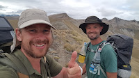
Neil has been staying too. No doubt it has been interesting for Neil to put a face to a name since I talk about Karen a fair bit on track, and also vice versa, since I've been mentioning Neil a fair bit in the blog. It's been great having Neil along - while enjoying being home, it's good to be able to chew the fat about the track as well.

I'm determined to finish the track but have been going long enough that I'm really starting to feel the pull of home, so it'll be good to get back on track tomorrow to remind myself about the other part of my life right now - the walking, as opposed to eating, part!

Day 33 - Crooked Spur Hut to Rangitata River, 8km, 3 hours


Today was dominated by the decision whether or not to ford the Rangitata River. After a fair bit of consultation home to see what the river and weather was doing I decided I didn't like the forecast of rain in the mountains, together with the news that the river level had started to rise during the night.  Arrangements were duly put in place for Karen to play taxi and pick us up. One ruined Saturday for her, she's an angel! However it left us with a really easy few kilometres dropping down to Bush Stream, then down to the river.

This meant a fair few crossings of Bush Stream, which was quite high, up to about bum level in places. The first crossing didn't go so well for me; I ended up grovelling around on hands and knees with water up to my chin, but the rest of the crossings were much better.

Within 3 hours we were at the car park, then 45 minutes spent having a dip in the stream and some lunch saw Karen turn up and a trip home to Rangiora for a few days.


Sunday 4 March 2018

Day 32 - Royal Hut to Crooked Spur Hut, 15km, 5 hours 30 minutes


Having spent a day and a half in Royal Hut I was on the point of leaving, with pack donned, when I discovered the back of the door of the hut. A treasure trove!  It was littered with the names of parties involved in autumnal droving runs, who obviously based themselves out of this hut, and included some proper New Zealand royalty.

One name was particularly noteworthy. 
Harry Ayers is without doubt the most famous mountain guide in New Zealand's history, bar none. Today he is best known as the man who guided/taught Sir Ed to climb throughout the Southern Alps, but this is to only brush the surface of his accomplishments. A genuinely exciting discovery to see his name up on the door, and on VE day no less!

The door had other famous names in New Zealand mountaineering, including Gottlieb Brawn-Elwert, who died while guiding then Prime Minister Helen Clark close to this hut (actually just the other side of Stag Saddle, where we had just come from).

Back to more prosaic matters. I'm going to have to start varying my diet soon. The unchanging texture of dehydrated food is starting to do my head in.

We're still in pretty big country, however with a fairly short day and not an undue amount of climbing, just a lot of up and down I expected an easy day, especially after coming off a zero day.


I was surprised therefore to find the day tough going. My legs had plenty in the tank but cardio-wise I just couldn't get in the zone today. I've been struggling with meals a little, but have been making sure to get through most of my food. 
Nevertheless I wouldn't be surprised if that has something to do with it.

In any case we had a decent break at Stone Hut on the way past before pushing on reaching a saddle with fantastic views after a short but testing climb up a scree slope...

... it was then an easy few kilometres to our hut for the night, itself having fantastic views to the Rangitata River.

Tomorrow will be interesting. All the SOBOs we have passed in the last few days have promised hell and brimstone on the few kilometres down Bush Stream to the river, with tales of unfordable maelstroms abounding. Most New Zealanders we have passed have been more optimistic, so I'm expecting some excitement but no particular issues getting to the Rangitata.

Crossing the Rangitata, which I have been hopeful of doing, might be a different story. It is still significantly higher than it normally is this time of year, as a result of the recent cyclone. We did talk to one SOBO who crossed it today, but it was flowing swiftly at belly button height for him. With rain forecast for the mountains that's marginal to say the least. I promised Karen before starting that I wouldn't be fording anything deeper than waist deep. Crossing with Neil would make the crossing easier though, so we'll see how the chips fall in the morning.

Day 31 - Royal Hut, 0km


A zero day, the first since Southland. All my other rest days since have been on hiatuses (hiatii?) in towns.

A day to dry out the tent/boots/clothes, sunbath, dip in the river, read and eat. Bliss!

Saturday 3 March 2018

Day 30 - Roundhill Ski Area to Royal Hut, 24km, 7 hours 30 minutes


Tenting out last night I was hoping to wait for the next hut 8km away for my ablutions but, when nature calls...
Fortunately there was a rabbit hole ideally placed. No digging required on my part, but no doubt one very shocked rabbit. Never mind, quid pro quo for all the rabbit droppings I've been walking over for the last 4 days.

The walking day started with an easy 5km of picturesque trail...


... before dropping to the Coal River and some fairly slow route finding upstream and an impromptu swim by Neil.


Within 90 minutes we'd made it to Camp Stream Hut, a fantastic little private hut with a large stack of fire wood that would make for a brilliant little weekend destination in from the Roundhill road end. We were only staying for lunch, but the $10 cost of staying there would have been well worth it.


After lunch, like most TA walkers, we left the official trail which followed a valley, instead climbing onto a sublime ridge with magnificent 360 degree views. Only a matter of 20km to the northwest was Aoraki, the other mountains bordering the Grand Plateau and the main divide. Unfortunately on our day this was largely hidden in cloud, but such was the scenery that this hardly detracted from the grandeur of the scene, with 2500+ meter high mountains dotting the landscape at seemingly all angles.

The ridge was some of the easiest climbing on the trail so far, a really easy gradient and took us across the 650km mark on the trail. HALF WAY!!! So momentous that it called for an inter centenary thumbs up.

As always the views kept improving as we climbed. The high point on the whole trail is Stag Saddle at 1950 meters. It seemed a shame to top out just below 2000, and with the newly named Beuzenberg  Peak (named after a Mt Cook guided, deceased on a fall with 2 clients) easily climbable from the ridge at 2070 meters we carried on up. Feeling privileged to stand in such a place I started to reel off photos, none of which really capture the majesty of the place.


Then it was down a long scree slope on the other side of the mountain. We had 700 meters of altitude to lose, and only 4km to the hut to do it in.


The day was bookended by another hour and a half of difficult river route finding. I was getting tired and this section seemed to go on forever.


But we eventually made it to Royal Hut, so named because Prince Charles and Princess Anne were once choppered in here for tea. I think I earned it more!


Tuesday 27 February 2018

Day 29 - Lake Tekapo to Roundhill ski area, 26.3km, 6 hours 15 minutes


I was thrilled to get a bed in the backpackers last night. I wasn't quite so thrilled to be in a room full of kiwi experience travellers, none of whom saw the need to turn off the light until after 1am.

So a late start this morning then. With sore feet after days of gravel walking and another 15km of it in prospect for today, I decided to tape the balls of my feet, the first time in weeks that I've needed to.

After breakfast in Tekapo, and having stocked up with bakery goodies for lunch it was time to hit the road.
There isn't much to say about the road walking, we (I say 'we', I'm walking with Neil again) worked our way up the north shore of Lake Tekapo before taking to the hills, the last of the big alpine lakes left behind.


We climbed on a generally easy gradient away from the lake, receiving a very welcome surprise when the low cloud that had obscured the mountains all day started to lift late in the afternoon.

Being treated to phenomenal views it didn't take too much thought to end the day short of the hut that had been our destination, set up camp in a semi sheltered spot beside a nicely bubbling brook, and enjoy the views for the evening.
Tenting at 1100 metres we've probably let ourselves in for a cold night, but the views were worth it!

Week 4 summary

7 days walked, ignoring the long hiatus back home for Jakob's birthday and dodging the weather.

I started the week at Lake Hawea and end at Lake Tekapo about to climb out of thing Mackenzie Country, having covered 172km.

A lot of gravel walking has left me with very sore feet and I still have a few niggles in my legs, but generally I'm in pretty good nick physically. A 4 day break helps in that regard!

The back still does well with minimal voltaren required.

Onward away from the alpine lakes and further into Canterbury!